Visiting the Pond Complexes
Eden Landing Ecological Reserve
Visit the Restoration
Volunteer Activities at Eden Landing Ponds
Hunting
Eden Landing is open for hunting on selected hunt days, with access available first-come, first-served up to 100 hunters. Find out more at the Reserve webpage. California Department of Fish and Wildlife license counters have permanently closed post-COVID. More information can be found on its Licenses and Permits page.
Audio Tour at Eden Landing
Eden Landing audio tour from YourWetlands.org.
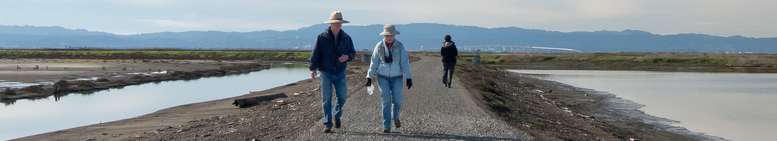
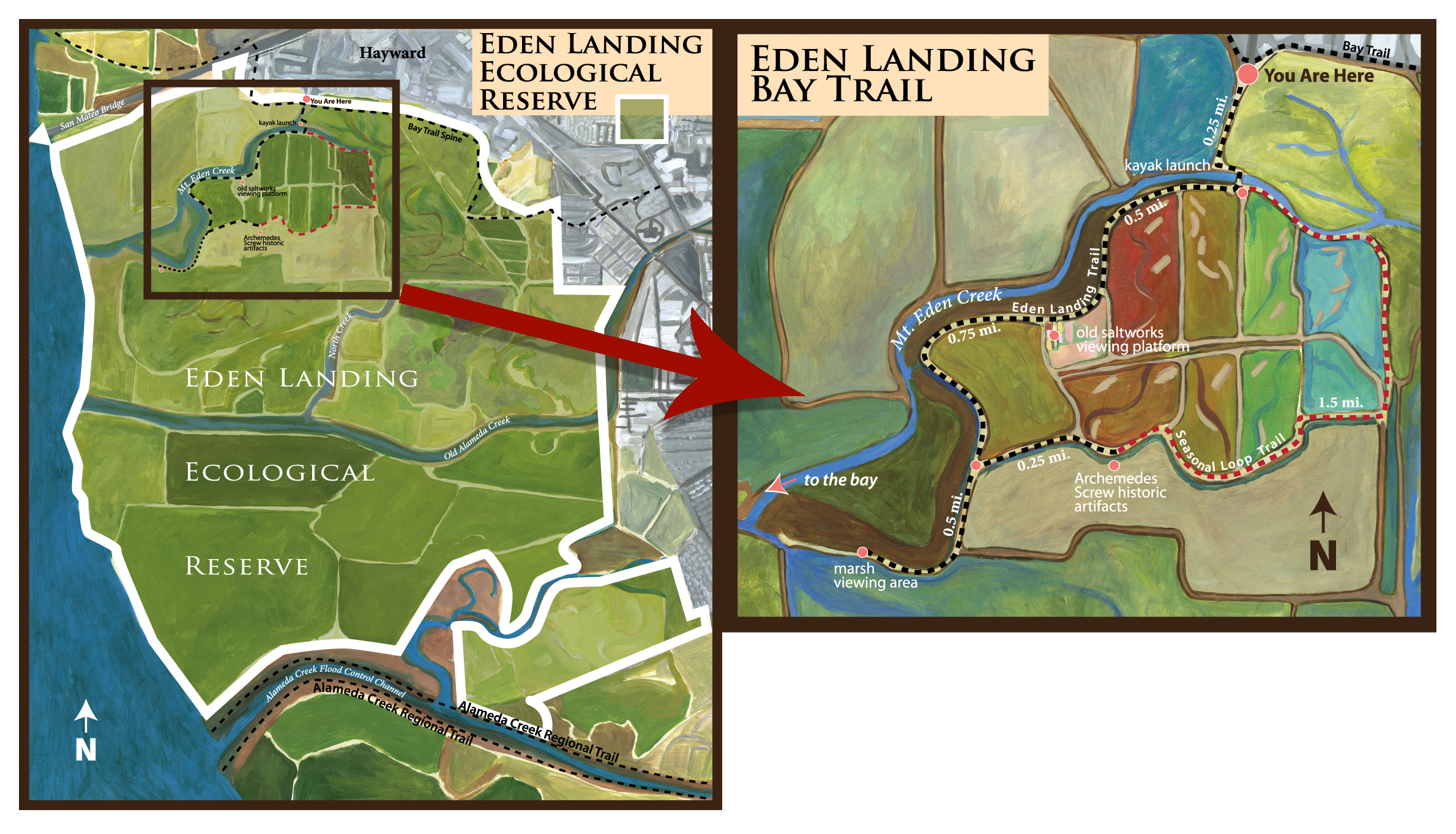
Eden Landing trails, kayak launch, shorebirds and saltworks ruins
Eden Landing Ecological Reserve offers new hiking, kayaking and sight-seeing options. Along with a segment of the Bay Trail, the Reserve now hosts a 3-mile seasonal loop trail around shorebird ponds and 19th Century salt-making sites. An all-year trail passes saltworks ruins, where a boardwalk and panels allow in-depth viewing and learning. A spur route ends at marshes near the edge of the Bay. Another spur reaches historic Archimedes screws, windmill pumps used to move water for salt-making. Because of potential wildlife impacts, no dogs are allowed on trails (additional provisions apply for waterfowl hunts). A new accessible launch, with a drop-off loop, provides Bay access for kayakers and other non-motorized small boats. Limited hunting is allowed at Eden Landing.
More information:
For a map and more information on hunting, history and restoration, see the California Dept. of Fish & Wildlife Eden Landing Ecological Reserve website.
Detailed information on the kayak launch, a trailhead of the San Francisco Bay Water Trail, is available on the Water Trail website's Eden Landing trailhead page.
See a photo and text guide to the main Bay Trail spine in Eden Landing (circa 2010) by Bay Trail enthusiast Ron Horii.
Directions:
From westbound Highway 92, take the Clawiter Road/Eden Landing Road exit. Go left at the light, over the overpass, and continue straight at the stop sign. Follow Eden Landing Road south of the highway to the end, near the intersection with Arden Road.
From eastbound Highway 92, take the Clawiter Road/Eden Landing Road exit and turn right at the stop sign at the end of the exit. Follow Eden Landing Road south to the end, near the intersection with Arden Road.
Print and Online Media
Upcoming Events
Events for the public include free guided tours, classes, or volunteer opportunities to help grow plants, restore habitat, clean up wetlands, or help scientists and wildlife.
Here are our past events.

- Sat, 05/10/2025, 9:00am – 1:00pm
- Sat, 07/12/2025, 9:00am – 1:00pm
- Wed, 05/14/2025, 11:00am – 12:00pm

- Sat, 06/07/2025, 9:00am – 12:00pm
Construction Milestones
-
2019
Managers finalize plan for Eden Landing Phase 2 restoration, recreation and flood protection construction
-
2016
A kayak launch and 3.8 miles of new trails open to some of the Bay's oldest salt-making ruins: the 19th Century Oliver Saltworks ruins and Archimedes screws, old windmill-like water pumps
-
2015
230 acres of ponds are optimized for shorebirds and ducks, with new nesting islands and roosting mounds. The ponds also offer a range of water salinities and levels to test which levels birds prefer (Ponds E12/E13)
-
2011
Greater numbers and species of native fish are using restored and enhanced ponds, including the threatened longfin smelt, scientists report.
-
2011
630 acres of ponds are breached to the Bay to begin natural salt marsh restoration (ponds E8A, E9, and E8X)
-
2010
Project managers launch planning for Phase 2 construction projects, dialoguing with stakeholders and members of the public at periodic public meetings.
-
-
2008
A new experiment to scatter oyster shells in nesting areas of the threatened Western snowy plover is designed to camouflage similarly-colored eggs and chicks from predators.
-
2008
The project launched a $4 million scientific research and monitoring effort, engaging a variety of academic, government, non-profit and private sector researchers on more than 20 studies on key scientific questions.
-
2007
Project managers finalize a 50-year Restoration Plan! The Plan establishes an adaptive management process, so that ecological factors guide the extent of salt marsh restoration; based on scientific data and the needs of multiple protected species, the Project will restore from 50% to 90% of the ponds to salt marsh.
-
2007
The Project launches three public Working Groups to guide Phase 1 design and construction at each pond complex.
-
2006
Based on extensive public and stakeholder dialogue, managers finalize three alternative Project-wide plans for consideration and environmental analysis: a 50/50 split between tidal marsh and ponds; a 90/10 split between tidal marsh and ponds; and no change.
-
2005
Thousands of shorebirds and ducks began returning to ponds now managed for wildlife instead of salt production.
-
2004
Project managers begin transforming the ponds from industrial salt-production sites to feeding and nesting spots for migratory birds in a 3-year initial stewardship plan to dilute salty water and optimize water levels.
-
2003
Project managers launch an intensive public planning process, including a 25-member Stakeholder Forum and many additional public workshops.
-
2003
The Project's National Science Panel forms to advise on the role of science in the restoration.
-
2003
State and Federal agencies and private foundations acquire 15,100 acres of commercial salt ponds in the South Bay from Cargill Inc. for $100 million. The South Bay Salt Pond Restoration Project launches to oversee multi-decade restoration of the ponds to achieve wildlife habitat, recreation, and flood protection goals.
Documents Related to this Pond Complex
SBSP Phase 1 Restoration Alternatives Maps |
Stakeholder Assessment |
2008 RFP Awards for Phase 1 Selected Monitoring and Applied Studies Topic 1: Measuring Habitat Evolution Utilizing Satellite Imagery |
Advisory Council on Historic Preservation National Historic Preservation Act Section 106 Completion Letter (January 2013) |
Permit No. 7-03—Bay Conservation and Development Commission (October 14, 2008) |
Final Amendment to Regional Board Permit (February 2012) |
Identification and Evaluation of the South San Francisco Bay Solar Salt Industry Landscape (March 9, 2009) |
BCDC Permit for CDFW's O&M at Eden Landing |
Water Quality Data |
South Bay Salt Pond Habitat Evolution Mapping Project 1 Data |
2010 South Bay LIDAR Data |
Bathymetry Data |
Tide Gauge Data |
Inventory of Water Monitoring Activities |
Pond Breach Dates |
2008 RFP Awards for Phase 1 Selected Monitoring and Applied Studies |